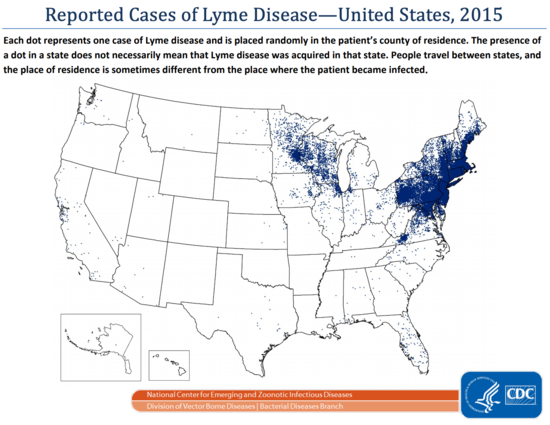
Let's say you're considering moving your nonprofit out of the Bay Area, and are considering somewhere in the Hudson Valley, perhaps near Peekskill NY. Looking at CDC maps it seems like Lyme is something to consider:
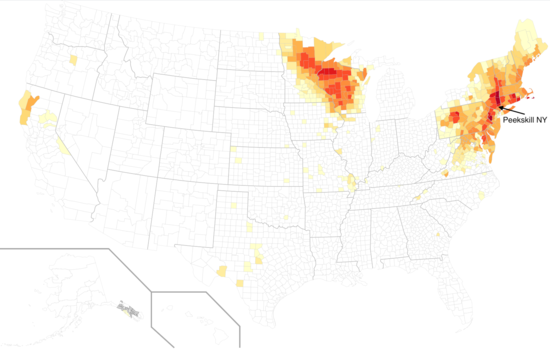
The dots are close enough together in the Northeast, however, that this map implies more uniformity than there actually is. Several years ago I made a map, coloring each county by Lyme incidence 1992-2011, and the Hudson Valley is really pretty bad:
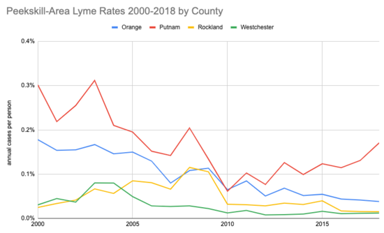
What do things look like with more recent data? I went back to the CDC site and downloaded their public use dataset. It has annual cases by county, 2000-2018. Peekskill is in the far North-West corner of Westchester County, surrounded by Putnam, Orange, and Rockland. Even though it is in Westchester, so much of the Westchester population is farther South that my guess is Putnam is probably a better proxy?
Taking population data from the census, here's the annual rate for each county:
Putting these percentages in perspective, a 0.1% annual rate represents 1 in 1,000 people getting it each year, and if you stayed for 20 years you'd roughly have a 1 in 50 (2%) chance.
Mostly this makes me sad that no one has decided to manufacture the FDA-approved Lyme vaccine LYMErix, whose patent expired in 2014.
(I would like to update my map with this new data, but there are artifacts I need to look into first.)


Similarly, they have: "Each year, approximately 30,000 cases of Lyme disease are reported to CDC by state health departments and the District of Columbia. However, this number does not reflect every case of Lyme disease that is diagnosed in the United States every year. Standard national surveillance is only one way that public health officials can track where a disease is occurring and with what frequency. Recent estimates using other methods suggest that approximately 476,000 people may get Lyme disease each year in the United States."
https://www.cdc.gov/lyme/datasurveillance/index.html